BOISE, Idaho — Late spring is typically the time when the weather focus shifts to the warmer temperatures and thunderstorms. Typically, people don't think about the snow - unless they're the ones in charge of monitoring river levels.
That's what the Army Corps of Engineers and the Bureau of Reclamation do. The two government entities control water levels on the Boise River and ensure that the reservoirs are full.
Both agencies, along with the Natural Resource Conservation Service, study how much snow remains on Idaho mountains post-season and the duration the rivers will be at their current height.
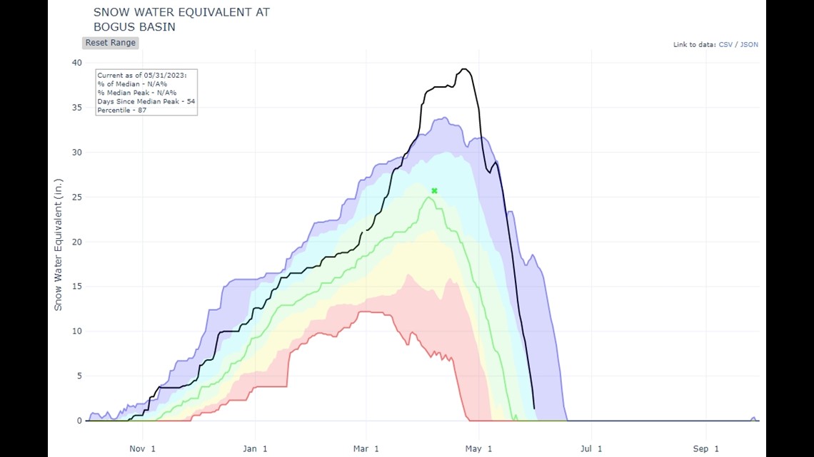
In general, snowmelt is winding down in the higher elevations. At the Bogus Basin SNOTEL site (pictured below), snow is expected to last only one more week - the first week of June.
The black line in image below represents 2022-2023 snow levels and presence. When the black line reaches the x-axis (the flat line/bottom of the graph), that indicates zero trace of snow.

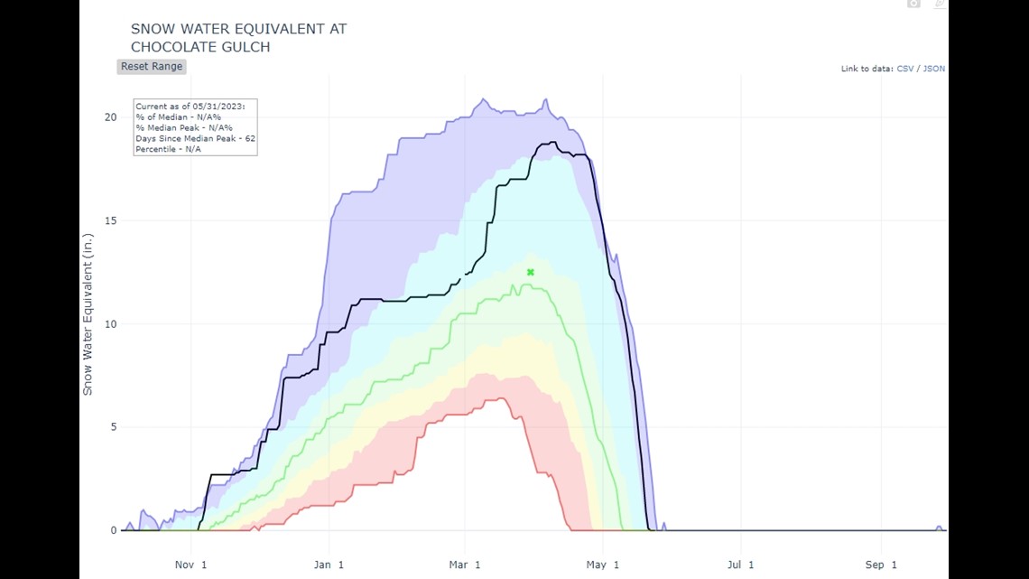
The Chocolate Gulch SNOTEL site (pictured below) is the closest site to Sun Valley, where all the seasonal snow has already melted. The graph displays this as the black line meets x-axis. It's a late snowmelt for the area, but not the latest they've observed.

Finally, the Jackson Peak site (pictured below), east of Lowman is still recording the presence of snow. The black line has yet to reach the bottom of the graph. This elevation at this site is about 1,000 ft. higher than Bogus Basin and Chocolate Gulch.

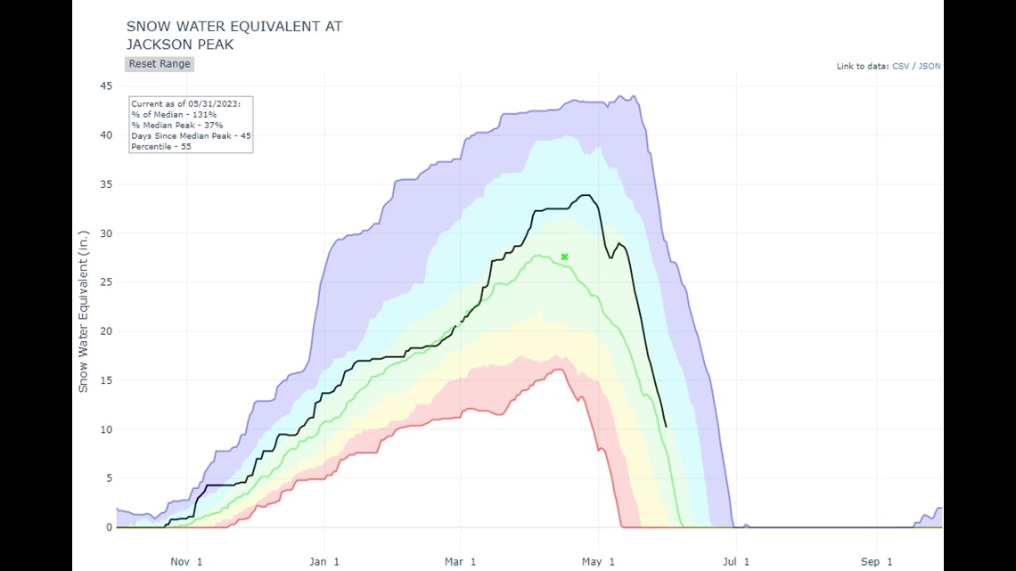
So, without even leaving the KTVB studio, it can be determined that the amount of snow remaining, is at 6,500 ft in elevation or higher. However, these individual sites don't necessarily provide and all-inclusive picture.
For example, if the site is located on the western side of the mountain, but all the recent storms have been coming in from the east, then the eastern side will have a lot more snow.
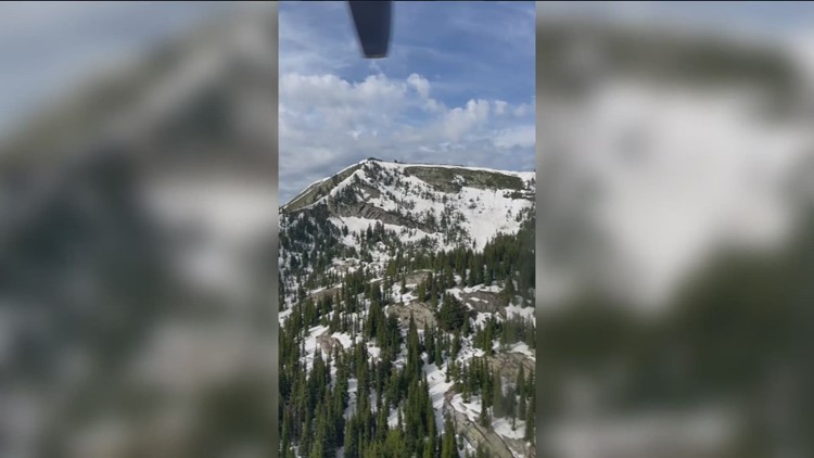
So, for greater comprehension, a small group of scientists from the aforementioned agencies evaluate some of these SNOTEL sites via helicopter, to visually observe how much snow is left.
"There are just enough potential risks there, so we want to make absolutely sure," said Jon Roberts, Water Management Program Manager for the Army Corps of Engineers. "So, we have scientists and engineers go out and actually check and verify the extent prior to filling a reservoir system in some of these large, populated or impactful areas," said Roberts.
Roberts mentioned that these flights serve as a final assessment before making the decision to fill the reservoirs. But understanding flood risk is also a major factor the agencies must heavily weigh.
"So, we often hear about problems in winter with rain or snow events that can drive a lot of flash flooding," said Roberts. "The same thing can happen when we're doing our final fill. If we combine it with just the little bit of snow that's left, and then we have no space in the reservoir system, it can cause problems for everyone downstream."
"So, that's the primary reason we're really checking...to confirm there's no risk left before safely filling the reservoirs," continued Roberts.
Roberts added the heli-flight provided the agencies the information to conclude that even if there were a substantial amount of late spring rainfall, there is currently not enough snow to cause flooding in Boise.
However, the official flood stage for the Boise River is at 7,000 cubic feet per second (CFS), as of May 31. We start seeing impacts along the greenbelt at 4,000 CFS. So, we'll likely avoid flooding in Boise this season, but the river will still be running high.
Watch more Local News:
See the latest news from around the Treasure Valley and the Gem State in our YouTube playlist: