BOISE, Idaho — The Air Stagnation Advisory was lifted at 2:00pm on Friday setting the stage for better air quality in the Treasure Valley throughout the weekend. Valley locals woke up to chilly rain and wind gusts between 20-25 mph on Saturday morning after the Friday night's wind and storm system disrupted the inversion.
Scattered rainfall continued throughout the day with up to a half inch predicted for Saturday.
Friday night's storm system also welcomed a winter wallop to the Central and Boise Mountains! A Winter Weather Advisory kicked off Friday night at 11pm and is expected to end at 5am Sunday morning. During this time, 5-10" inches of snow is expected in the mountain valleys while up to 3' of snow is expected at 6,000' and above in the Boise and West Central Mountains as well as the Camas Prairies.
🚨 The National Weather Service emphasizes hazardous road and driving conditions on Highways 55, 21, and 20 at 4,000' and above on Saturday night. Roads could present with difficult-to-impossible conditions. Experts advise local travelers to prep for emergency situations by keeping flashlights, food, water, and blankets in their vehicle.
A Winter Storm Warning enters the mix at 2am Saturday and is expected to end at 5am Sunday morning. Between 5-12" of snow is expected at elevations below 7,000'. Throughout the greater Sun Valley region, up to 2' of snow is expected above 7,000'.
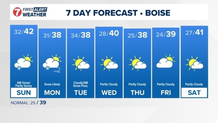
An inch of snow is likely to dust the Treasure Valley Sunday morning, but lingering inversion conditions should have completely scoured out by Sunday afternoon introducing sunny skies and the atmosphere's return to warmer valleys and cooler mountains. Monday evening into Tuesday morning another system briefly visits the Treasure Valley followed by high temps returning to seasonal norms and partly sunny skies through Friday! 😊


