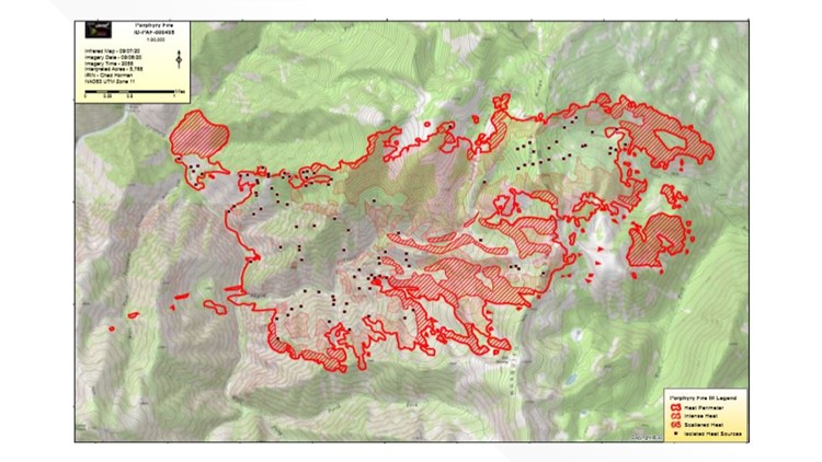
YELLOW PINE, Idaho — A wildfire burning north of Yellow Pine has grown to 5,768 acres by Monday morning, forest officials say.
The Porphyry Fire is burning in the Frank Church River of No Return Wilderness along the Porphyry Creek drainage. High temperatures and gusty winds helped push the fire, and it is expected to remain active throughout the day.
At this point, there is no safe access for fire crews, officials say.
The Porphyry Fire was sparked by a lightning strike on Aug. 25. An area closure was put in effect Monday through 11 p.m. Monday night.
"The public is reminded to remain cognizant of fire activity in the area and be alert even when outside of the closure area," fire officials wrote.
The full list of closures is included below:
• National Forest System (NFS) Trail # 122: NFS Trail # 122 is closed beginning at the junction with the NFS Trail #180 at the Hettinger Ranch and terminating approximately 8 miles downriver at Chicken Creek.
• NFS Trail #125: NFS Trail #125 Porphyry Creek the entire 5.7 miles of this trail are closed, from the southern intersection with NFS Trail #122 at the Porphyry Creek Bridge, continuing east/northeasterly to the junction of NFS trails at Chicken Peak.
• NFS Trail #003: NFS Trail #003 Mosquito Ridge is closed from the trailhead at NFS Road #373 Pueblo Summit Road running northerly 12.6 miles and terminating at the junction located at Fourway Junction with NFS Trail # 020 at the northern boundary of the closure area
• NFS Trail # 123: NFS Trail # 123 Rattlesnake is closed. Beginning at the trailhead located off of the Pilot Peak Lookout Access Road (NFS Road #341) traveling northerly along the ridgeline that comprises the boundary of the Frank Church River of No Return Wilderness to Rattlesnake Peak, continuing northerly along the wilderness boundary, then traveling east/northeasterly to the South Fork Salmon River, following 50’ off of the southern side of the Rattlesnake trail and terminating at the lowermost switchback on this trail where it turns southerly and heads up river across from the Hettinger Ranch.
• NFS Trail #018: NFS Trail #018 Horse Heaven Trail is closed beginning at the junction with NFS Trail #020 Hen Creek and continuing 2.5 miles south to its junction with NFS Trail # 003, and 125 at Chicken Peak.
• NFS Trail #019: NFS Trail #019 is closed beginning at the western junction with NFS Trail #003 Mosquito Ridge Trail and continuing 2.5 miles east to its junction with NFS Trails #014 and 015 at Cow Corrals.
• NFS Trail #016; NFS Trail #016 Beaver Creek Trail is closed beginning at the junction with NFS Trail #014 Boulder Creek and continuing Northwesterly 4.33 miles to its junction with the NFS Trail #003 Mosquito Creek Trail